
Street Art Panorama Street View: What It Shows and Misses

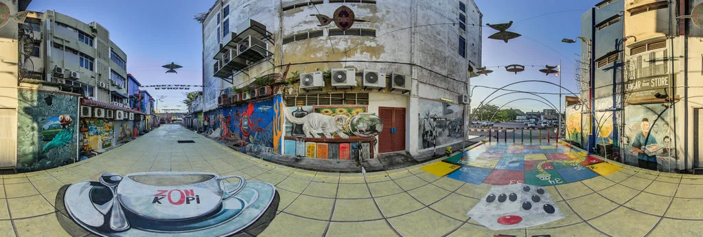
A street art panorama street view is a geotagged 360° photograph of a wall or mural captured at a specific moment. It documents what was there on that date; it does not prove the work still exists, and later buffs or repaints may not appear.
What Is a Street View Panorama in Street Art?
A Google Street View street art panorama is a 360° image of a wall, not a live video feed. Google Street View launched in 2007 and stitches together billions of such images. The capture date appears in the interface, so a viewer can see when the camera passed. A panorama is georeferenced to a point on Google Maps; shifting between frames moves the viewpoint, but the wall itself does not update. That gap between capture and current condition is the basic limit of this format. It also raises the question of how documentation moves into digital spaces.
How Street Art Was Documented With Panoramas
Street art was documented by capturing a 360° image at a mural, stitching frames, and placing the panorama on a map. The Street Art View project, active from 2011 to 2015, mapped murals as geotagged points so users could explore them in Google Street View. Later, Google Arts & Culture expanded the approach with digital street art collections and allowed users to submit images.
A street art 360 panorama was built in these steps:
- A mounted or backpack camera recorded the wall from a single point.
- Software stitched the frames into a navigable sphere.
- The image was geotagged to a map location.
- Curators added artist, title, or location details when available; otherwise, the record carried only the capture date and coordinates.
For a local example of mapped walls, see documented walls in Shoreditch.
What a Panorama Can and Cannot Tell You
A panorama can show what was on a wall at one moment; it cannot tell you what is there today. The table isolates the difference.
| A panorama shows | A panorama does not show |
|---|---|
| A 360° image of a wall at one moment | Whether the mural exists now |
| The capture date visible in Street View | The date the artwork was painted, unless metadata says so |
| A geotagged point on Google Maps | Who holds current rights or permission |
| Visual condition at capture time | Later buffs, repainting, weather damage, or demolition |
Because a capture is a snapshot, claims about a wall’s present state work best with “reported by” and “attributed to” plus a date. That phrasing avoids presenting an old panorama as proof that a mural still stands.
How to Verify a Mural Before You Go
To find street art on Google Maps, open the panorama and check its capture date before assuming the wall still looks the same. The urban art routes article describes the jump from a digital map to the real experience; the verification below keeps that jump honest.
- Note the capture date in Street View: on desktop it appears in the top left, and on mobile it appears below the location.
- Search recent photos from the same street or a nearby geotag dated after the capture.
- Check local press or gallery records for removal, restoration, or a new sanctioned wall version.
- If no recent source appears, treat the panorama as a historical record. This is slower than a glance, which matches the advice to document urban art without haste.
Street Art Panorama Terms Worth Knowing
These terms help describe the distance between a panorama and the physical wall. They sit within the broader history behind ephemeral works.
- site-specific: made for one place; the wall’s context shapes the work.
- ephemeral: expected to disappear or degrade; many street pieces are short-lived.
- buff: removal by painting over; a buffed wall may remain visible only in an old Street View capture.
- sanctioned wall: a legal, often commissioned surface where murals may last longer, but still not guaranteed.
- attributed to / reported by: precise phrases for uncertain authorship or a non-current source.
FAQ
What is street art panorama street view?
A geotagged 360° Street View capture of a mural, showing one moment, not live status.
Can I still find street art on Google Street View?
Yes, but only as dated captures; the wall may have changed since.
How do I know if a mural from Street View still exists?
Check the capture date, then search recent photos or local sources; if none exist, say “reported” or “attributed to”.
Sources
Google Street View — official guide to panoramas and capture dates. Google Arts & Culture — digital collections and street art documentation.
Keep reading